


GPS Waypoint Finder

Descrizione di GPS Waypoint Finder
Uses the GPS sensor, Magnetic Field Sensor and Accelerometer to determine the distance and direction to a GPS waypoint. Does not need to be held level. Free & No Ads.
Normally a compass needs to be level to get the correct reading, but this app uses the accelerometer reading to convert the magnetic field reading back to the horizontal plane.
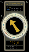
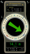
In addition to the direction and distance to the waypoint, a compass ring shows the current heading. North points to True North (i.e. The direction is corrected for the magnetic declination - the difference between magnetic north and true north).
The GPS reading and the time since that reading is shown at the bottom of the screen.
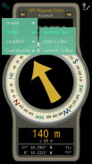
Use for geocaching, finding your car, hotel, or other locations.
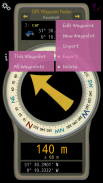
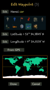
• Store up to 500 waypoints.
• Imperial or Metric units.
• Import and Export waypoints as GPX files.
Arrow colour changes to green at less than 30m and blue at less than 10m to make it easier for littler ones to identify that they've reached the waypoint.
Whilst walking, look where your going, not at the app or you might trip! The app tells you the direction of your destination, not how to get there.
Only as good as the sensors in your device. Use for Indication Only.
</div> <div jsname="WJz9Hc" style="display:none">Utilizza il sensore GPS, sensore di campo magnetico e accelerometro per determinare la distanza e la direzione verso un waypoint GPS. Non ha bisogno di essere tenuto livello. Gratis e senza annunci.
Normalmente una bussola deve essere a livello per ottenere la lettura corretta, ma questa applicazione utilizza la lettura accelerometro per convertire il campo magnetico rilettura al piano orizzontale.
Oltre alla direzione e la distanza verso il waypoint, un anello della bussola indica la direzione corrente. Punti Nord a True North (cioè la direzione è corretta per la declinazione magnetica - la differenza tra il nord magnetico e il nord).
La lettura GPS e il tempo dal momento che la lettura è mostrato nella parte inferiore della schermata.
Uso per il geocaching, trovare la vostra auto, hotel o altri luoghi.
• Memorizza fino a 500 waypoint.
• le unità imperiali o metriche.
• Importazione ed esportazione di waypoint come file GPX.
Arrow colore diventa verde in meno di 30 metri e blu a meno di 10 metri per rendere più facile per quelli meno molli per identificare che hanno raggiunto il waypoint.
Mentre a piedi, guardare dove la vostra intenzione, non a l'applicazione o si potrebbe scattare! L'applicazione ti dice la direzione della vostra destinazione, non è come arrivarci.
Solo buono come i sensori nel dispositivo. Utilizzare a titolo indicativo.</div> <div class="show-more-end">
GPS Waypoint Finder - Versione 1.00
(04-04-2016)
GPS Waypoint Finder - Informazioni APK
Versione APK: 1.00Pacchetto: com.keuwl.gpswaypointsUltima versione di GPS Waypoint Finder


 3.55
3.55
 3.17
3.17
App nella stessa categoria

Potrebbe piacerti anche...


